Explore the

Morris Canal

The Vision Behind the Morris Canal

In 1824, the Morris Canal & Banking Company (MC&BC) was chartered to construct a canal that would transport Pennsylvania coal to growing markets along the eastern seaboard. By passing through New Jersey’s iron district, the canal provided the critical transportation system needed to foster economic growth. Towns like Dover and Rockaway, once quiet settlements, transformed into thriving industrial hubs. The canal opened in 1831, and by 1836, it extended from Newark to Jersey City, connecting to New York Harbor.

An Engineering Marvel Across New Jersey

Spanning 102 miles, the Morris Canal stretched from Phillipsburg on the Delaware River to Jersey City, overcoming the rugged terrain of New Jersey’s highlands. To manage an elevation change of 1,674 feet, engineers designed 23 lift locks and 23 water-powered inclined planes. These groundbreaking structures could raise or lower canal boats up to 100 feet at a time, making the canal an engineering triumph of its era.

The Lifeline of Commerce

Mule-drawn boats, capable of carrying up to 70 tons of cargo, navigated the canal in five days. During its peak, hundreds of boats transported coal, iron ore, and agricultural products, driving commerce and industrial development across northern New Jersey. The Morris Canal was New Jersey’s first industrial transportation system, reshaping the region’s economy and laying the groundwork for future progress.

The Decline and Legacy of the Morris Canal

By the early 1900s, the canal had become obsolete due to advancements in railroads and other transportation systems. In 1924, the canal was officially dismantled, and ownership of its water resources—including Lake Hopatcong, Lake Musconetcong, and Greenwood Lake—was transferred to the state of New Jersey.

Preserving History Through the Morris Canal Greenway

Today, the Morris Canal Greenway, a collaborative effort led by the Canal Society of New Jersey and local communities, works to preserve the canal’s historic remains. The initiative focuses on interpreting key sites, educating the public, and creating recreational opportunities. Through these efforts, the legacy of the Morris Canal continues to inspire and connect us to New Jersey’s rich industrial past.

Detailed Information

Length of main canal

  • Phillipsburg to Jersey City: 102.15 miles

Length of Pompton Feeder

  • Feeder Lock to Mt. View (Mead’s Basin): 4.26 miles
  • River Towpath, Feeder Lock to Pompton: 1.75 miles

Elevation changes

  • Mean tide at Jersey City to summit near Lake Hopatcong: 914 feet
  • Summit to low water at Phillipsburg: 760 feet
  • Total change in elevation: 1,674 feet

Costs

  • Original: $2,104,413
  • Enlargement: $1,700,000

Number of inclined planes

  • Phillipsburg to Jersey City: 23

Number of locks

  • Lift locks: 23
  • Guard locks: 11

Canal dimensions

  • Original canal: Surface, 32 feet wide; bottom, 20 feet wide; depth, 4 feet
  • Enlarged canal: Surface, 40 feet wide; bottom, 25 feet wide; depth, 5 feet

One-way trip

  • Phillipsburg to Jersey City: 5 days

Motive power

  • Number of mule teams: 2
Inclined planes Inclined planes used water power to raise or lower canal boats as much as 100 feet at a time. Water from the upper canal level was used to create the motive power to raise and lower the boats. The water then flowed back in to the next lower level and was used over and over farther down the canal. The original inclined planes, built in the 1820s, used a counter balance system powered by an overshot water wheel. Although these planes worked, they were not powerful enough to be economically successful. When canal engineer William Talcott redesigned the planes in the 1850s, he used more powerful cast-iron reaction turbines. The new planes could raise and lower boats carrying 70 tons of cargo.
  • Prior to the use of wire cables, iron chains were used.
  • The grade of the inclined planes varied from a ratio of 1:11 to one of 1:20.
  • Plane 9 West, Port Warren near Phillipsburg:
    • Largest plane on the canal; formerly owned by author James Lee
    • Vertical lift: 100 feet
    • Length: 1,510 feet to the summit; 1,788 feet end to end
    • Approximate time for transit: 12 minutes

Locks Lock dimensions:
  • Original locks, 9 feet wide x 75 feet long in the chamber
  • Most enlarged in 1840-41, 11 feet wide x 95 feet long in the chamber
  • Most enlarged again by 1860 to a clear length 100 feet in the chamber

Boats Capacities:
  • Early boats: 25 tons of cargo
  • 1845 Section boats: 44 tons of cargo
  • 1860 Section boats: 70 tons of cargo
  • Section boats were built in two sections and hinged together so that they could be disconnected when traversing the canal’s inclined planes.

Dimensions of 1860 boats:
  • Length: 87.5 feet
  • Width: 10.5 feet
  • Depth: 4.5 draft when loaded
  • Total weight of boat, cargo and cradle: 110 to 125 tons.

Inclined planes used water power to raise or lower canal boats as much as 100 feet at a time. Water from the upper canal level was used to create the motive power to raise and lower the boats. The water then flowed back in to the next lower level and was used over and over farther down the canal. The original inclined planes, built in the 1820s, used a counter balance system powered by an overshot water wheel. Although these planes worked, they were not powerful enough to be economically successful. When canal engineer William Talcott redesigned the planes in the 1850s, he used more powerful cast-iron reaction turbines. The new planes could raise and lower boats carrying 70 tons of cargo.

Canal Reservoirs

  • Lake Hopatcong: A dam, built by the MC&BC, raising the level of Great Pond a total 11 feet to create the primary water source that would fill both the east and west divisions of the Morris Canal.
  • Greenwood Lake and the Pompton Feeder: In 1836 the MC&BC acquired the right to dam Long Pond to create a canal reservoir now called Greenwood Lake. Water passed down the Wanaque River to a 4.26 mile long feeder that joined the main line of the canal at Mead’s Basin, now Mt. View.
  • Lake Musconetcong: In 1845 the canal company increased its water supply once again by damming the Musconetcong River at Stanhope to create a new reservoir that we now know as Lake Musconetcong.

Aqueducts

  • Little Falls Aqueduct across the Passaic River: Supported by a stone arch spanning 80 feet
  • Pompton Aqueduct between Mountain View and Lincoln Park:
    • 1830 aqueduct: 236-foot span on 9 stone piers
    • Circa 1850 aqueduct: 275-foot span on 6 stone piers

Long Levels

  • Bloomfield to Lincoln Park: 17.5 miles
  • Saxton Falls to Port Murray: 11 miles
  • Washington to Lock 7 West: 7 miles

Year
1845
1850
1855
1860
1866
1871
1875
1880
1885
1890
1895
1900

Total
58259
239682
533204
707631
889220
629044
451045
503486
364554
394432
270778
125829
27392

Coal
12567
98100
290730
404464
459175
329584
250047
427606
301654
297417
259778
119479
20411

Iron Ore
5802
60055
113294
186064
290165
185482
99607
44897
21803
54889
0
0
0

Other Cargos
39890
81527
149180
117103
139880
113987
101390
30987
41095
42125
11153
6350
6981

Gross Income
$18,997
$94,224
$272,125
$350,710
$616,350
$283,725
$270,216
$215,667
$101,487
$120,283
$208,557
$111,072
$52,076

The peak year for tonnage and profits was 1866.

Iron Mine Railroads
Numerous tramways and railroads were built to bring ore from mines to the docks on the canal. Most eventually became through railroads.

  • Dell Mine Tramway
  • Hibernia Mine Railroad
  • Mount Hope Mineral Railroad
  • Mount Hope Tramway
  • Ogden Mine Railroad brought iron ore from the mine to Nolan’s Point on Lake Hopatcong; here it was loaded into canal boats.
  • In 1880, 108,000 tons of ore were moved in 1,500 boatloads.
  • Sussex Branch Tramway and Railroad

Nov 15, 1822 | Act to investigate the feasibility of the canal passed

Dec 31, 1824 | Morris Canal & Banking Company chartered by the State of New Jersey

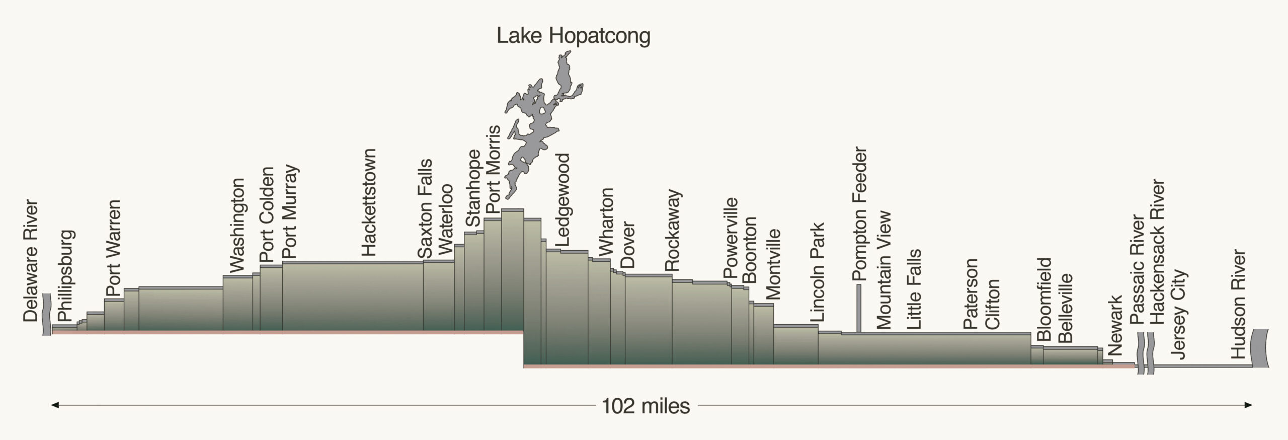
Jul 12, 1825 | Construction starts near the present town of Ledgewood

Nov 4, 1831 | First trip from Newark to Phillipsburg

1832 | First full boating season

1836 | Jersey City extension completed – 11.75 miles

1844 | Company is reorganized

1849  | Banking privileges eliminated

1841 & 1845 | Canal enlargements

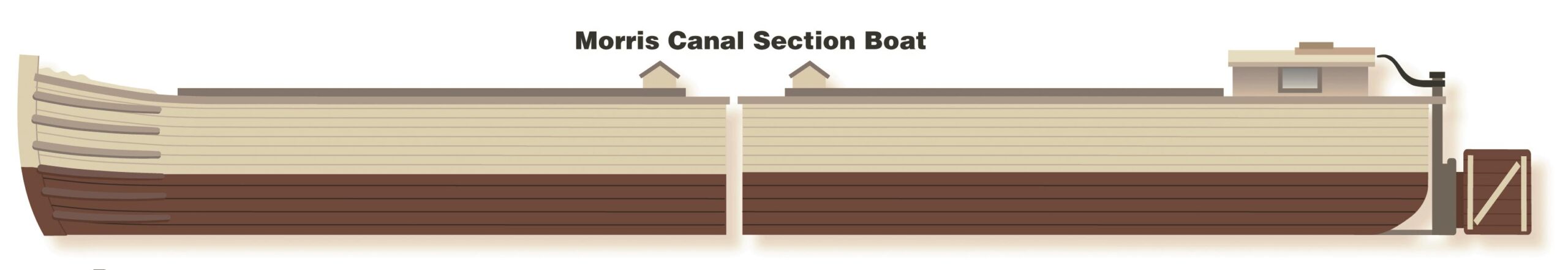
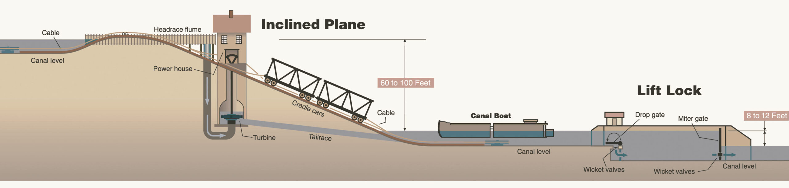
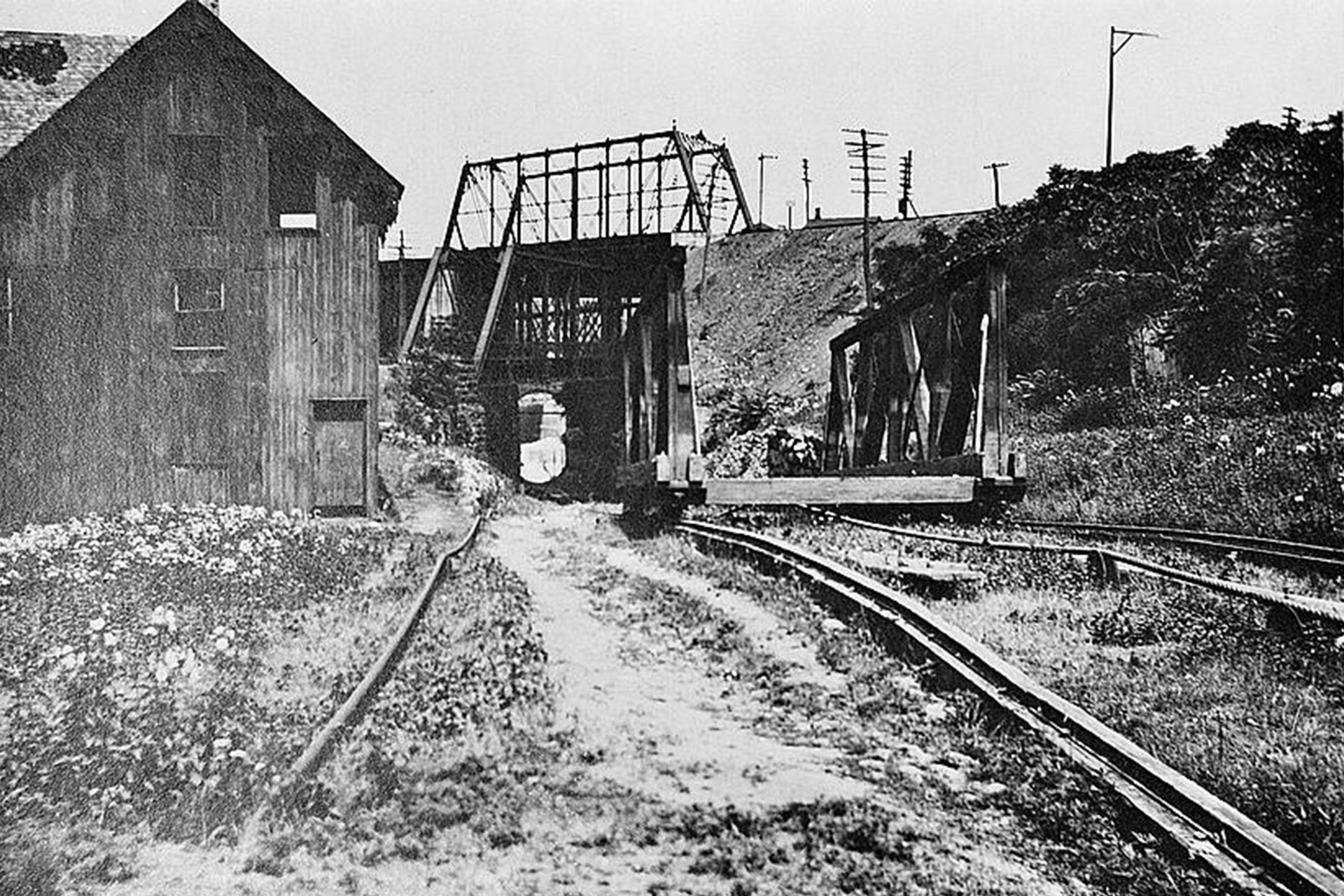
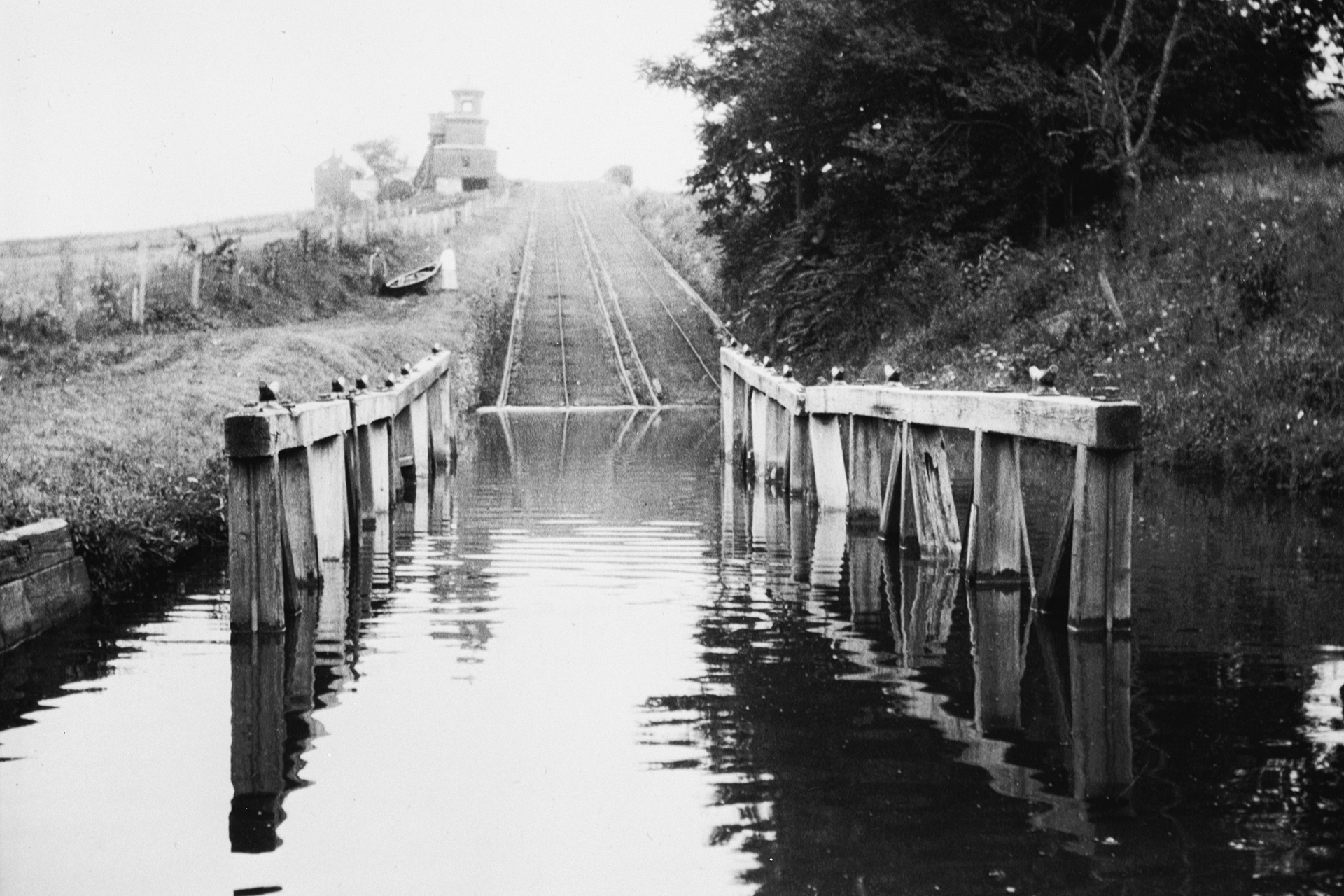
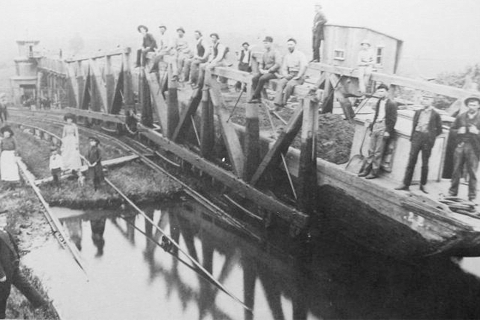
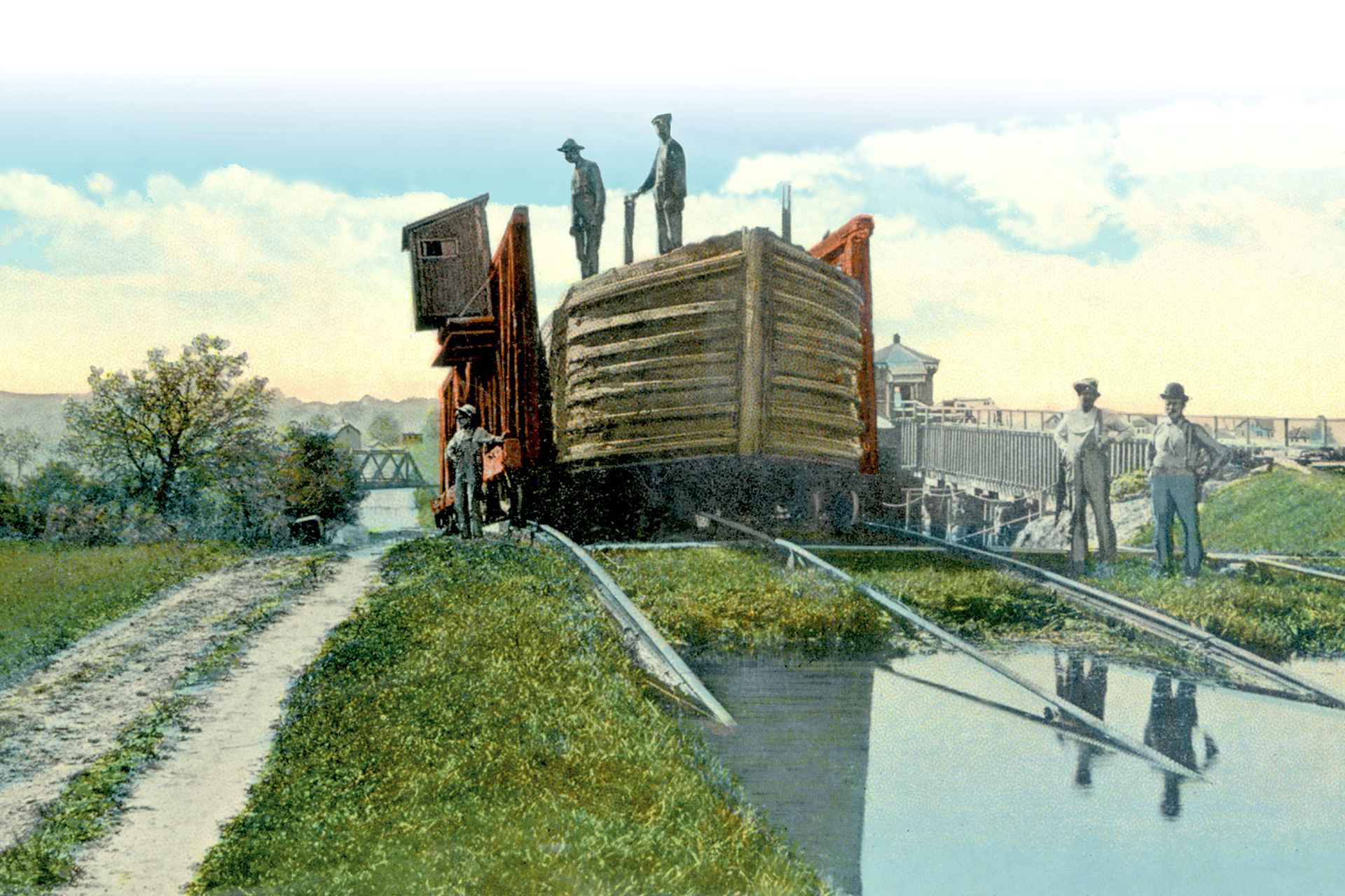
1847 – 1860 |  Inclined planes rebuilt to accommodate boats with 70-ton cargos

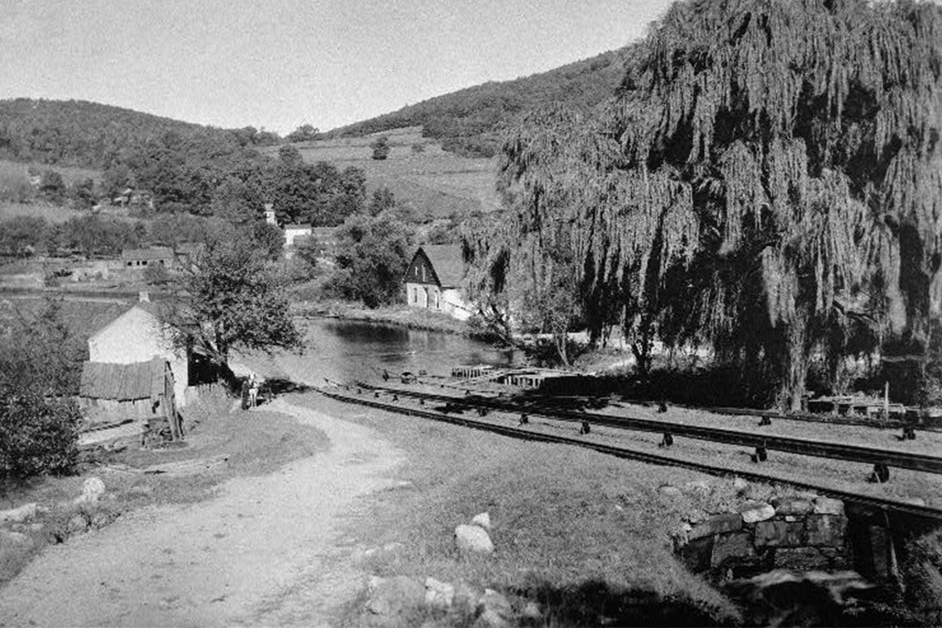
1856 – 1870 | DL&W Railroad transports coal from northern fields to the canal docks at Washington

1871 | Canal leased by the Lehigh Valley Railroad for 999 years (in perpetuity)

Nov 29, 1922 | State of New Jersey takes over the canal

Spring, 1924 | Canal drained

Dec 31, 1974 | MC&BC charter was due to expire in 1974. However, the company still exists as part of the State of New Jersey DEP

Photo Gallery